How Keswick Road got its name
Most people in Evergreen know that Keswick Road changed names at some point. But it actually happened twice. Here is the story as told by following old maps.
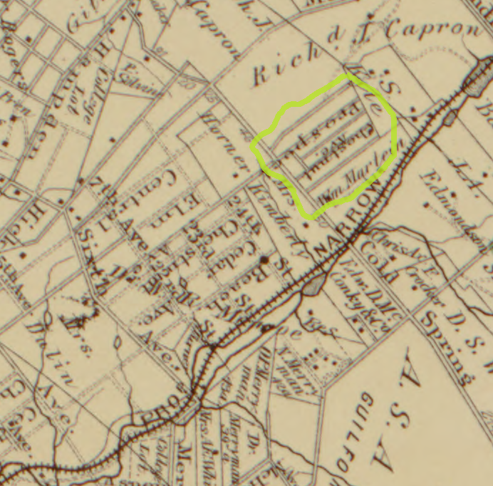
When Evergreen was chartered in 1873, the first street plans included what we know today as Schenley, Keswick and Wilmslow. On map 2 from 1878, Schenley was known as Prospect Avenue and Keswick is shown as Chestnut Avenue. Wilmslow Road (not shown) started out as Ashland Avenue.
As was common, new roads that lay along the alignment of existing roads received the same name. Even if they were not connected now, they would most likely be connected in the future as cities continued to grow. Baltimore still has many examples of disjointed sections of road sharing the same name: there is more than half a mile between the two segments of Rockrose Avenue: one west of Reisterstown Road, the other in Woodberry. Closer to home, Wilmslow itself has two disjointed sections. Map 2 from 1878 shows other sections of Chestnut and Cedar with dashed lines in what is now Plat 5 of Roland Park, but these plans preceded the Roland Park Company, and were never realized.
Looking at a modern map you can see that Chestnut Avenue in Hampden still aligns with Keswick Road in Evergreen. But following Keswick south, it makes a zigzag as it crosses the lanes of University Parkway and no longer lines up with Chestnut. But it did align with Cedar Avenue, which ran from the southern tip of Hampden to what we know today as 40th street. So, as shown on map 3 from 1898, Chestnut Avenue in Evergreen became Cedar Avenue sometime after 1878.
But why change to Keswick?
We can thank the Roland Park Company for that.
When Roland Park laid out its first Plat 1 surrounding Evergreen on the west and north, they did not reuse any existing street names. They didn’t even want a connection with Evergreen. The first layouts on map 3 show Schenley and Keswick dead-end against the gardens of the homes on Oakdale. The extension of Keswick north into Roland Park was initially called Notre Dame Avenue, but quickly changed to Forest Road as shown on map 4.
In 1911, the Roland Park Company submitted its design for Plat 5. As map 5 shows, Plat 5 ran up to Merryman Court and Northfield Place. Today’s Keswick neighborhood was still undeveloped. Northfield Place curved south to Somerset Road. That only left a short 720’ section of road from Somerset through Overhill to University Parkway. That’s what was called Keswick. Keswick straddled the City and County border, which since the expansion of 1888, ran halfway between Overhill and University Parkway. In 1918, Baltimore City expanded again and absorbed Evergreen, but that did not change any of the street names. The City Directory of 1923 still lists Keswick as Cedar Avenue. (https://msa.maryland.gov/bca/baltimore-city-directories/index.html)
In the 1920s, development started on the Keswick neighborhood. Northfield Place was extended north to Coldspring Lane. Map 6 is an aerial photo from 1926/1927 and shows that the first new homes in Keswick were built on the west side of Keswick Road. It is also the first time Cedar Avenue is identified as Keswick. This renaming and renumbering must have been a significant event, but it is not clear when exactly that happened, and if at the same time the entire course of Cedar Avenue down to Sisson Street was renamed as well. This piecemeal construction of Keswick also explains the slight curve near Northfield Place and the small offset as it crosses Cold Spring at the traffic lights.
So, there you have it. Keswick was named after a little section of road that the Roland Park Company refused to call Cedar and it got that name because of the development of what is now known as the Keswick neighborhood. If it wasn’t for that, we would still be living on Cedar, and our neighbors across Cold Spring might be living in the Cedar neighborhood!
Links to the source files of the maps:
Map 2